Pre 4.1 Terrain
88 files
-
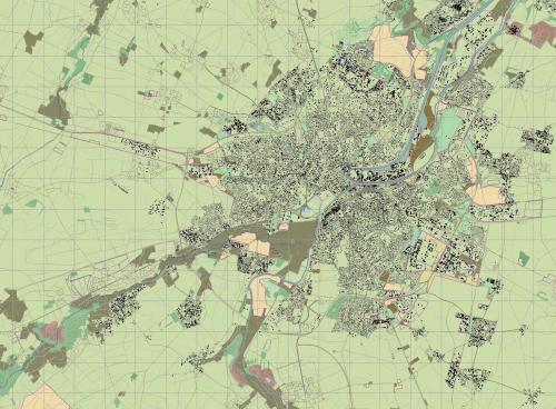
Basic Wolfsburg Terrain map from OSM
By DarkAngel
Someone mentioned this to me in a PM but can't remember who?. Here is a basic terrain map for Wolfsburg Germany derived from OSM data. It is a good starting block for someone or several someones to develop. There is pretty good coverage of land use and excellent road data, though that isn't to say it couldn't be improved. This is for use with the revised Wolfsburg Heightmap Wolfsburg_Germany_rev.hgt.450 downloads
(0 reviews)0 comments
Submitted
-

small afghan map
By 29 stumps
A SMALL MAP THAT MIGHT BE GOOD FOR TANKS AND APC TRAINING, SOME VILLAGES FOR TALIBAN TO HANG OUT.445 downloads
(0 reviews)0 comments
Updated
-

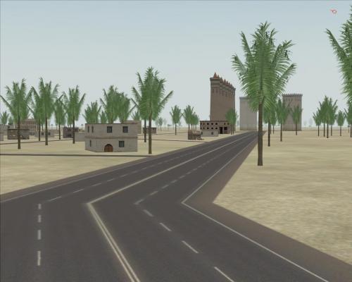
IRAQ TOWN
By 29 stumps
MY FIRST MAP ATTEMPT, ALSO THANKS TO DASKAL FOR HIS THUNDER ROAD MAP TEMPLAT . ITS JUST A SMALL IRAQ TOWN WITH A LOT OF BUILDINGS AND HWY SYSTEM413 downloads
(2 reviews)0 comments
Updated
-

Golan Heights 1973 (3.011)
By LtGeorge
Basic terrain map with most of the Israeli side of the Golan Heights filled in. Includes key villages on both sides. Does not include small details such as tank ramps or low-level roads or trails. Border is based on the 1973 Purple Line.404 downloads
(1 review)0 comments
Submitted
-
EGYPT MAP
By 29 stumps
A MAP OF TWO CITYS IN EGYPT FOR SOME BATTLE ENGAGEMENTS. I APPRECIATE SOME FEED BACK IN THE COMMENTS AREA. IM STILL LEARNING ON HOW TO MAKE MAPS FOR THE COMMUNITY. THANKS397 downloads
(0 reviews)0 comments
Updated
-

TIGRIS RIVER MAP
By 29 stumps
Quick 2 hour map for the community. I want to THANK EVERYONE who made mods and maps over the years, And also a BIG THANKS to the CREATORS of this AWSOME SIM .385 downloads
(0 reviews)0 comments
Submitted
-

Tskhinvali Georgia
By DarkAngel
Terrain Map of Tskhinvali Georgia as requested by Toyguy. This is derived from OSM data379 downloads
(1 review)0 comments
Submitted
-
 (1 review)
0 comments
Updated
-

Munster Germany terrain Demonstrator
By DarkAngel
Here is a map of the Munster area in Germany. This map is a request from someone who is working on the map. Please do not edit this version and upload it. It is uploaded to showcase a new way of populating maps with buildings. Where the data is available maps like this are possible in a reasonably short period of time.371 downloads
(3 reviews)0 comments
Submitted
-

Um Saad Revisit
By DarkAngel
Here is another map to demonstrate new techniques. This is the Northern border region between Egypt and Libya and was the scene of major fighting in 1977 when these countries had a border war. This map is suitable for someone who wants a small mapping project.371 downloads
(2 reviews)0 comments
Submitted
-

NGP_Bergedorf
By DarkAngel
60 x 40 km area of the North German Plain east of Hamburg. As requested by Hermes. This is Generated from OSM data.358 downloads
(0 reviews)0 comments
Submitted
-

Fulda Gap (Alt) 2
By DarkAngel
A revisit of the Fulda Gap map. The original was too far east. This is moved 30-30km west to better represent the are in which fighting would probably have taken place.
Map is developed using OSM data and I have included the different stages of development for anyone who is interested.
354 downloads
(1 review)0 comments
Submitted
-

Pahkajarvi Training Area, Finland
By Zipuli
This is a map of the Finnish Army training area Pahkajärvi, in south east Finland, near Karelian Brigade. In this area, the Finnish Army conducts live fire exercises and manouvers with infantry, armoured vehicles, anti-tank weapons including ATGMs, mortars, field artillery, multiple launch rocket systems, etc.
- Map size: 20 x 20km, covering the whole training area and its surroundings.
- Height map is DTED3 (10m resolution), 2012 data
- Terrain map by Zipuli and pvt Järvinen, KYMJP
- 5 theme files included for all seasons
See you at Loiri! Bring Your Own Bombs!353 downloads
(5 reviews)0 comments
Updated
-

Rovajarvi, Finland
By Zipuli
Welcome to Rovajarvi training area, Finland. It's one of the biggest training grounds in Europe, located in the northern third of Finland between towns of Rovaniemi and Kemijarvi. Here the Finnish Defence Forces train especially in the use of artillery and anti-tank weapon systems, but from time to time the Army uses the area for large scale maneuvers, like the "Trombi" ("Tornado") exercise in 2013 between two battalion battlegroups along with all the supporting arms. The terrain is just as difficult as the climate: During mid summer the sun does not go down at all and during the heart of winter the soldiers cope with endless darkness, frost and deep snow. Whatever the time of year, the flocks of reindeer get in your way and these animals are stubborn enough to stop an advancing mechanized battalion on their tracks, not giving way, and sometimes running straight into artillery splash zone when the grenades are already in the air... Reindeer meat anyone? Truly a place to take the military equipment to their limits:
https://www.youtube.com/watch?v=OvmBuk39e9k&list=UUM8qGnJrcCGQXCZuGenvrOQ (mechanized units in action during "Trombi 2013")
It's recommended to use the Suomussalmi -map themes, that come with the installer, with this one.348 downloads
(1 review)0 comments
Submitted
-

Gotland Terrain
By DarkAngel
Gotland map as requested by KT (and others). Data was sourced for me by Profevil.343 downloads
(1 review)0 comments
Updated
-

Bekibekibekistan (3.025)
By cata
Bekibekibekistan terrain file using the 29 Palms height map332 downloads
(1 review)0 comments
Submitted
-
Kouvostoliitto, Finland (3.0)
By Zipuli
An update to the map that comes with SB Pro PE 3.0.
Version 1.1:
Added detailed areas of
- In the north from Jaala to Tuohikotti
- Kaipiainen and Sippola towns
No navmesh to keep the file size smaller. Create one when making a scenario, or in the map editor.315 downloads
(1 review)0 comments
Submitted
-

Columbus GA (2.654)
By Rhyfel
working map of the downtown Columbus GA. Started from the baseline Ft Benning map provided by ESim Games.313 downloads
(0 reviews)0 comments
Submitted
-

Training Area Münsingen WINTERVERSION
By Nachtfalke
This training area was closed in 2007 ( South Germany near Stuttgart) This map is a winterversion. Snow Situation like at January to March312 downloads
(8 reviews)0 comments
Submitted
-
Golan Heights Revised Terrain Map
By DarkAngel
Terrain map derived from OSM data for the revised Golan Heights Heightmap (see height section). There are no buildings available yet for this region in the data set.295 downloads
(1 review)0 comments
Submitted
-

Palava, CZ Terrain map
By DarkAngel
Palava region of Cz as requested by JustSomeGuy
Map is created from OSM data.290 downloads
(1 review)0 comments
Submitted
-

Iraq Kuwait NW Border (94x94km) (terrain file)
Terrain file for the Iraq Kuwait NW Border (94km)
Special thanks to Gibson who helped me with the project.
278 downloads
(0 reviews)0 comments
Updated
-

Klietz, Germany Terrain
By DarkAngel
Klietz Area as requested by Eisen. Map is created from OSM data. I have included the different iterations for anyone interested in the stages of the process. The Klietz_1C.ter is the most complete version.264 downloads
(1 review)0 comments
Submitted
-
Ljubljana Gap Terrain Map
By DarkAngel
Ljubljana Gap as requested by AlesMrak (Dr Jones). This is derived from OSM data. Contains around 40,000 buildings.263 downloads
(0 reviews)0 comments
Submitted
-

Triades_Flussebene_Modified_v5_Map
By enigma6584
A nice little remake of a European style map. The map has some interesting tactical possibilities. For example; plenty of cover and concealment for mech scouting operations, open terrain for fast and large mech ops, strongpoint defenses in the cities covering avenues of approach, major river to cross with three bridges on map to defend or take. Good atmosphere for European operations in both west and easter areas.249 downloads
(1 review)0 comments
Submitted