Pre 4.1 Terrain
88 files
-

Schwarmstedt-Bergen-Munster_summer.ter
By Abraxas
From SCHWARMSTEDT in the South-West, crossing River ALLER, NTA BERGEN and MUNSTER-SOUTH towards military airfield FASSBERG and UNTERLÜß in the East. A revised and enlarged map to West-East-grid line 90.5 is available.
Screenshots of the terrain you can see on www.steelbeasts.org/Editorforum/Kartenerstellung/Bergen!
With the version 4.250 this map is no longer required and is automatically replaced by the supplied map "Bergen-Soltau-Munster"!
648 downloads
-

Fulda Gap The Southern Corridor V3
By WarUlf
This is V3 of the Fulda Gap The southern corridor map.2,117 downloads
(15 reviews)0 comments
Updated
-
(14 reviews)
0 comments
Submitted
-

Training Area Münsingen
By Nachtfalke
This training area was closed in 2007 ( South Germany near Stuttgart)565 downloads
-

Fulda Gap (Alt) 2
By DarkAngel
A revisit of the Fulda Gap map. The original was too far east. This is moved 30-30km west to better represent the are in which fighting would probably have taken place.
Map is developed using OSM data and I have included the different stages of development for anyone who is interested.
354 downloads
(1 review)0 comments
Submitted
-
BATUS Terrian
By 12Alfa
To be used with BATUS Map V4.23
Located in Southeast Alberta, approximately 50 kilometres west of Medicine Hat, CFB Suffield has been the site of military training in the region since 1972. CFB Suffield is host to the largest military training area in Canada, conducting the largest live-fire training exercises in the country. The Manoeuvre Training Area covers 1,588 square kilometres of a 2,700 square kilometre base
Home of the British Training Unit in Canada
SS_10_19_59.bmp
134 downloads
(1 review)0 comments
Updated
-

NATO Training Ground BERGEN
By Eisenschwein
Biggest Training Area in GE 18 x 22 Km. Requires the SCHWARMSTEDT - SOLTAU height map.1,740 downloads
(4 reviews)0 comments
Updated
-

FULDA GAP 2015 (v3.023)
By Falli
The previous 2014 FULDA - BAD HERSFELD map was extended by additional 40%.
The former excluded HUENFELD sector is now completely integrated.
A big thanks goes to Eisenschwein(911) and his meticulous work for the HUENFELD-map, which I was allowed to use as a blueprint.
Around 2800sqm of German Hessia and Bavaria, thousands of km of German highways, streets, roads, dirt roads are expected to be driven on.
All themes were reworked so you´ll have a complete new understanding of the real conditions in this area.
Authors: Falli(911) + Eisenschwein(911)
Included:
- map 1989 with GDR border preparations
- map 2015 with open border Hessia-Thuringia
- FuldaGap height map
- 5 different, brandnew terrain themes (Spring, Summer, Autumn, late Autumn, Winter)
Successfully tested with v3.002, v3.011, v3.023
Origin:
Fulda Gap_alt: eSim Games
Recommended mods:
- German Roadsigns FULDA GAP 2015
- German Buildings Woodland
- German Buildings Winter
The files are licensed under Creative Commons CC BY-NC-ND 3.0521 downloads
(1 review)0 comments
Submitted
-
Alternative Golan revised
By DarkAngel
An alternative terrain map for the Golan revised map. Warning it looks horrible in the editor, this is so I can see what the terrain types are doing. This is a mix of OSM data with a soil based terrain. I've added tank ditches and bunker positions (hesco barriers). This requires 4.023 for the terrain tiles which are custom. Some of them may need some tweaking.
115 downloads
(1 review)0 comments
Submitted
-

Rovajarvi, Finland
By Zipuli
Welcome to Rovajarvi training area, Finland. It's one of the biggest training grounds in Europe, located in the northern third of Finland between towns of Rovaniemi and Kemijarvi. Here the Finnish Defence Forces train especially in the use of artillery and anti-tank weapon systems, but from time to time the Army uses the area for large scale maneuvers, like the "Trombi" ("Tornado") exercise in 2013 between two battalion battlegroups along with all the supporting arms. The terrain is just as difficult as the climate: During mid summer the sun does not go down at all and during the heart of winter the soldiers cope with endless darkness, frost and deep snow. Whatever the time of year, the flocks of reindeer get in your way and these animals are stubborn enough to stop an advancing mechanized battalion on their tracks, not giving way, and sometimes running straight into artillery splash zone when the grenades are already in the air... Reindeer meat anyone? Truly a place to take the military equipment to their limits:
https://www.youtube.com/watch?v=OvmBuk39e9k&list=UUM8qGnJrcCGQXCZuGenvrOQ (mechanized units in action during "Trombi 2013")
It's recommended to use the Suomussalmi -map themes, that come with the installer, with this one.348 downloads
(1 review)0 comments
Submitted
-

Mingachevir Terrain map
By DarkAngel
Mingachevir Terrain maps as requested by CharlieB. Created from OSM data (plus some tweaking).
170 downloads
(0 reviews)0 comments
Submitted
-

Palava, CZ Terrain map
By DarkAngel
Palava region of Cz as requested by JustSomeGuy
Map is created from OSM data.290 downloads
(1 review)0 comments
Submitted
-
(4 reviews)
0 comments
Updated
-
Salisbury Plain
By Stuart666
A terrain map of the Salisbury Plain training area in Southern England.574 downloads
(2 reviews)0 comments
Updated
-

Gotland Terrain
By DarkAngel
Gotland map as requested by KT (and others). Data was sourced for me by Profevil.343 downloads
(1 review)0 comments
Updated
-

Maps and height CANADA ONTARIO, Kingston, Gananoque and Napanee
By KKnispel
CANADA, ONTARIO, Kingston Maps. consist of 2 maps created from high quality Army vector maps.
90x90 km area WEST KINGSTON (Named NAPANEE) and 50x50 km area EAST KINGSTON (Named GANANOQUE).
Small issues like signs are placed on roads, and must be moved.
All buildings are same type and facing same way.
Have corrected it and added google maps features like small henge, rocks and swamps in the parts of the map, I have build scenaries, but not all over due to the large size of maps.
The Maps are build together with LEO MACDONNALD from CAN 1 armd div in the SB community.
200 downloads
(0 reviews)0 comments
Updated
-
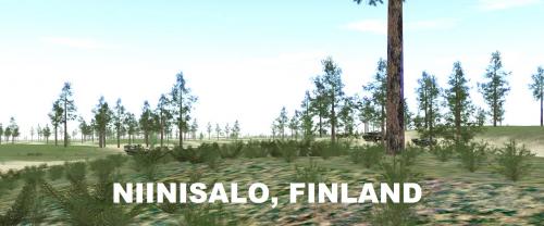
Niinisalo Training Area, Finland
By Zipuli
Welcome to Niinisalo! The 28x48 km area in this map covers the training grounds, used commonly by Finnish mechanized forces in maneuver and live fire exercises. The Pohjankangas -area north of Niinisalo Garrison provides a long open stretch of terrain that has subtle height variations, providing good hunting grounds for tanks, while the wooded areas surrounding allow mechanized infantry to fight dismounted.
Height and Terrain maps included. You can use Kouvostoliitto themes with this map.
Version 1.1 has some minor details added to Pohjankangas, along with more realistic vegetation (less visibility outside the "desert").566 downloads
(1 review)0 comments
Updated
-

Bekibekibekistan (3.025)
By cata
Bekibekibekistan terrain file using the 29 Palms height map332 downloads
(1 review)0 comments
Submitted
-

Klietz, Germany Terrain
By DarkAngel
Klietz Area as requested by Eisen. Map is created from OSM data. I have included the different iterations for anyone interested in the stages of the process. The Klietz_1C.ter is the most complete version.264 downloads
(1 review)0 comments
Submitted
-

Golan Heights 1973 (3.011)
By LtGeorge
Basic terrain map with most of the Israeli side of the Golan Heights filled in. Includes key villages on both sides. Does not include small details such as tank ramps or low-level roads or trails. Border is based on the 1973 Purple Line.404 downloads
(1 review)0 comments
Submitted
-

Greek Turkish Border (North) Terrain
By DarkAngel
Northern Portion of the Greek Turkish Border as requested by Iskios. Created from OSM Data.
196 downloads
(0 reviews)0 comments
Submitted
-
(1 review)
0 comments
Submitted
-
Golan Heights Revised Terrain Map
By DarkAngel
Terrain map derived from OSM data for the revised Golan Heights Heightmap (see height section). There are no buildings available yet for this region in the data set.295 downloads
(1 review)0 comments
Submitted
-
(2 reviews)
0 comments
Submitted
-

Meride EU terrain map
By AlphaSierra
Another fictional map with exceptional heightmap for armored warfare. Rivers, hills, small villages, cities, rolling landscape, deep canyons, military compounds etc.
Both terr and hgt file are in the file.
NOTE: This is a big file 74 mb
If you have questions how to install map, look here: http://www.steelbeasts.com/sbforums/showthread.php?t=6417623 downloads
(1 review)0 comments
Updated