MatsW
-
Posts
299 -
Joined
-
Last visited
1 Follower

MatsW's Achievements
")


-
Please tell us. 🙂
-
You can use Google Maps. Select the SW (down - left) corner of the area that will be your map. Copy the coordinates. Then measure 100 km north and 100 km east. Publish the coordinates and height and width of the area here on the forum. www.openstreetmap.org is a source of maps and map data. The quality varies but it is free.
-
120 x 120 km is the maximum size of one map in SB. The area you describe is about 430 km from North to South and 400 km from West to East. Even a 120 x 120 km map require a lot of work to accomplish.
-
We are still suffering from the old King Karl/Charles/Carolus XII words before the battle in Kliszów 1702 in Poland: "Hungry dogs bite best"....
-
CV9040 in Swedish ISAF texture with a mobile camouflage systems to reduce the thermal signature. Ongoing work....

-
Congratulations eSim to the first 10 years! All the best from Sweden! /MatsW
-
We use CH MFP/DX1 a lot because you can "translate" the keystrokes into functions (like W = Forward) so it shortens the time to learn different positions. Especially if the students rotate on different positions like Commander, Gunner and Driver. We more or less take away the ordinary keyboard and replace it with one or two MFP. The other use of it is to have a "real" panel (like gunners panel in CV9040) as background and use the keys for different functions on that panel. If you are an experienced gamer that just use one position more or less, you would probably find the ordinary keyboard good enough. Perhaps the more complicated keystrokes like CTRL DELETE would be good to simplify on a MFP. MatsW Swedish Land Warfare Centre
-
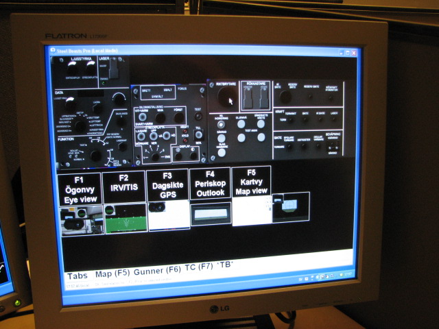
Hi Quagmire We use (zero) one or two for every client depending on the players position as TC or gunner. We have been testing different layouts including the one at Touchbuddy website but we have also configured some by ourselfs for the Strv 122 and CV9040. The touchscreen we use are some 10.1 inches with traditional 4:3. I have attached some pictures with one "SBPro screen", one mapscreen and one touchscreen with a TouchBuddy profile. It also shows a older version of the Multi Function Panel and the Leo2-gunner handle from AFVSim. I find the profile easy to setup and with fast response. We have only used it with SBPro so it´s hard to compare with any other sim. The Ronner.net link is from good old days but I will take it away shortly. Cheers MatsW
-
We have been using the TouchBuddy software with touchscreens now and then. We have a set up with one or two touchscreens for TC or Gunner for Strv 122 or CV9040. The software is simple to use and it reduces the time to learn SBPro functions compared to use an ordinary keyboard. Nickname "Zorlac" on Touchbuddy did help us. Best regards MatsW Edit: http://www.steelbeasts.com/sbforums/showthread.php?t=8178&highlight=touchbuddy
-
US_Brandenburg_374549N_862821V_40x40 version 1.1 will be uploaded shortly. The updated version have more buildings and other terrain features in the Irvington city area. Will see if there will be some update on the Brandenburg area some day.... /MatsW
-
Glad that you found it useful for your scenarios. I'll speed up the mapmaking for the next version. I will concentrate on Irvington city. /Mats
-
There will be a first version of height + terrain file in the download sections for US_Brandenburg_374549N_862821V_40x40 with focus for the Irvington area. It's Brandenburg and Irvington area in US, Kentucky. Not Brandenburg in Germany. The terrain file is the 1,0 version with terrain around Irvington but with not so many buildings. Hopefully, there will be more buildings in the next version. /MatsW
-

Version 1.1
811 downloads
Terrain file (version 1.1) for US_Brandenburg_374549N_862821V_40x40.<br /> It's Brandenburg and Irvington area in US, Kentucky. Not Brandenburg in Germany. Height file for the terrain maps is located in the height section. The terrain file is an updated version with more buildings in Irvington area. There will be a 1.2 version with more updates. -

Version 1.0
540 downloads
Height file for US_Brandenburg_374549N_862821V_40x40. It's Brandenburg and Irvington area in US, Kentucky. Not Brandenburg in Germany. Terrain file for the height maps is located in the terrain section. -
You can't be proud of everything from your country..... The ABBA-era had it´s both good and bad spinoffs.