4.1+ Map Packages
Base and delta maps for version 4.1+ of Steel Beasts.
1. Zip or RAR the folder containing your map package. If it is a delta map, then Zip/RAR the appropriate delta map folder inside the base map's "deltas" folder. If it is a new base map (ie. if its a completely new height map), then Zip/RAR the base map folder.
-
The path will be different based on where you chose to put the maps when you ran the maps installer.
2. Submit the file to the "maps" area in downloads.
-
Please provide a description and a few screenshots of your map.
3. We will prepare your maps for distribution, this will create a package unique ID (UID) for the map. We will upload the file to a public maps repository that the Steel Beasts Maps Download Manager service and Steel Beasts know how to use. At that point we will delete the Zip/RAR file from steelbeasts.com, and update the text of your description to include the UID of the map package for manual downloading
38 files
-

Al Fubar City map
By ben
Small middle eastern city with river crossing. Inspired by CMSF2 "Ambush in Al Fubar" mission.
To install the map simply download this scenario file to your scenarios and load it in Offline Session. The embedded map will be extracted automatically.
53 downloads
(2 reviews)0 comments
Submitted
-

Germany_Munster 2024
Updated high detailed map of Munster Nord & -Sued
The different THEMES are in the 911-Forum:
https://forum.steelbeasts.org/downloads/file/141-munster-themes/
Info for scripting: Let the AI units only driving slowly through the villages, because it's very tight and not much space for any movements.
To download this map with the map transfer manager, please use this GUID: bcdfb3d3-0356-4b0f-a74c-da88c1f86415
System (C) / ProgramData / eSim Games / Steel Beasts / maps / packages >> unzip! = Done✔️
ENJOY😎👍
93 downloads
-

Zealand_40x50
By Nike-Ajax
THE DOWNLOAD IS NOT THE MAP FILE - ITS A PLACEHOLDER. YOU NEED TO DOWNLOAD IT FROM ESIMS MAP SERVER.
But it would be nice if you pressed the "Download" here if you download it from the server - just to give me an idea about if you like it, thank you.
W part of the island Zealand in Denmark - 40 x 50 km map
- High resolution with full functionality
- Based on 1 m resolution LIDAR map
- Working bridges and buildings
- Not perfect but hopefully good enough
- Published
Copyright: This file is free for use in any non-commercial context and application
I have tried, but cant upload including in Zipped version here because its too big, but ...
I have made Esim upload it to their Map server (as the file even in compressed so .Zip form was almost 450 MB):
This is the map id (UID): 13c11a22-d668-4126-aada-6ebd1123316e If you use the map in a scenario, clients should auto download the map if they have the map transfer tools installed.
It should automatically download to your map file. If you need to place it manually, then the files in the download goes here (unless you made a custom install), in the folder called Ringsted (you need to make a folder called "Zealand_40x50" and put all 4 files in it) in the location below:
C:\ProgramData\eSim Games\Steel Beasts\maps
So looking like this:
(Or the equivalent in whatever language your PC is set up with)
44 downloads
- western zealand
- denmark
- (and 1 more)
-
Wasserkuppe 2
By Abraxas
I based this map on the period around 1990. I used the UTM maps of the Bundeswehr and the NVA (GDR), which differ somewhat in the level of detail, as well as Google Earth. Many areas have been added and some have been revised.
Installation path: ProgramData > eSim Games > Steel Beasts > maps > packages
90 downloads
-
Ringsted
By Nike-Ajax
SW part of the island Zealand in Denmark
- High resolution with full functionality
- Based on 1 m resolution LIDAR map
- Working bridges and buildings
- Published
Copyright: This file is free for use in any non-commercial context and application
I have tried, but cant upload Zipped version, but ...
The files in the download goes here (unless you made a custom install), in the folder called Ringsted (you need to make a folder called "Ringsted" and put all 4 files in it) in the location below:
C:\ProgramData\eSim Games\Steel Beasts\maps
So looking like this:
(Or the equivalent in whatever language your PC is set up with)
253 downloads
-

Eastern Europe map
By ben
Fictional Eastern Europe. Rural farmland and villages. Generally flat terrain. 10x10km.
To install the map simply download this scenario file to your scenarios and load it in Offline Session. The embedded map will be extracted automatically.
140 downloads
-

Taiwan North West Coast Delta Map (Grenada Map)
By cata
This is a map based on Taiwan's North West coast line and possible PLA landing beaches closest to Taipei. It's a very complex map, Be Warned! not a map for large AI battles as the terrain was built to simulate the close and difficult terrain of Taiwan. This is challenging for mechanized units, requires a lot of micro management. Also attached is a folder containing Taiwan building textures I used in the following screen shots and video, See original map thread for more screenshots and a video showing the maps features:
BuildingTextures.rar
116 downloads
-

European Farmland map
By ben
Detailed 13x12km area of European Farmland. Based on Ft Bragg heightmap.
To install the map simply download this scenario file here and load it in Offline Session. The embedded map will be extracted automatically.
Map Server UID = 4e4d6057-19df-41d0-ad73-4457d6d95773
271 downloads
-

Limnos Island Map ("ALTIS")
Limnos Island Map
Commonly known as ALTIS in the game ARMA III.
This project is maybe 50% complete, but I've been working on it since 2018 and I wanted to finally just get it published.
This is with great help from @MatsW, who kindly provided me the height map of the blank island of Limnos many years ago.
1. Every object you see in game is hand placed with the exception of the road network, which I also had to replace. Every bush, tree, house, and stream has been hand placed with consideration for the scale and terrain of the real life island but also adapted to the fictional island of Altis, which is just under 1/2 scale of the real island. This map has taken so long that I've actually had to revert back much work to update certain areas to Steel Beasts standards - for example - in 4.1 we were given terrain alteration tools which helped drastically, but that also meant going back and re-do much of the work that was already done. Recently, Custom Line objects were also added - this caused me to go back and deleted hundreds, maybe thousands, of standard Line Objects that I used across the map. This has taken a lot of effort.
2. Some of the villages are modelled accurately to ARMA III, but in many cases it wasn't possible due to many factors. The terrain in ARMA is smaller than 1/2 scale, so there was much more room in the 1:1 Steel Beasts version that I've made. The designers of the Altis island also made some drastic adjustments to the real life terrain, flattening many areas that aren't flat on the real life island of Limnos.
3. This map is an ongoing project and I assess it to be about 50% complete. The main area where the ARMA III campaign takes place is 'good enough' at this point, but everything on the west and northwest side of the island has been untouched. Areas that are incomplete show small streams as house outlines.
To Install:
Download the zip file and drop the contents in your Map Packages directory
C:\ProgramData\eSim Games\Steel Beasts\maps
160 downloads
(2 reviews)0 comments
Updated
-

African Desert Map (Ft Polk heightmap)
By ben
To get the map installed, just run the scenario in this download! The map is embedded in the .sce file 👍
The map is also available for download from the official Map Server with UID c59833e4-decf-43da-bddf-0c2e66c492e5
188 downloads
(2 reviews)0 comments
Updated
-

KIEW-EAST
By WarUlf
KIEW-EAST V4 50x48 km is based on open-source GIS data.
DTM is DTED2 (30m) Vector data is OSM whit manual attribution for treelines Image/Raster map is based on GeoTiff 1m The Villages and allotments areas are Geo-typical with use of typical building models to minimise the polygon/textures as much as possible.
The Industrial, Retail, Apartments, Military and commercial areas have been extruded from Building footprints to approximated heights and use GeoTypical textures.
Map has been optimized to speed up loading times.
130 downloads
-

KIEW-WEST-V8
By WarUlf
KIEW-WEST V8 40x53km is based on open-source GIS data.
DTM is DTED2 (30m) Vector data is OSM whit manual attribution for treelines Image/Raster map is based on GeoTiff 1m The Villages and allotments areas are Geo-typical use of typical building models to minimise the polygon/textures as much as possible.
The Industrial, Retail, Apartments, Military and commercial areas have been extruded from Building footprints to guessed heights and use GeoTypical textures.
Map has been optimized to speed up loading times.
128 downloads
-

PROCHOROVKA 1943
By WarUlf
Prochorowka 1943, 61x47km is based on old Russian Military maps, historical info and combined with Modern open source GIS data.
Note that the notorius anti-tank ditch is integrated into the terrain map.
102 downloads
(0 reviews)0 comments
Updated
-
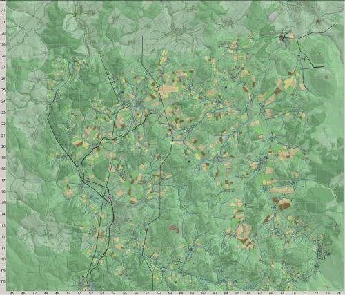
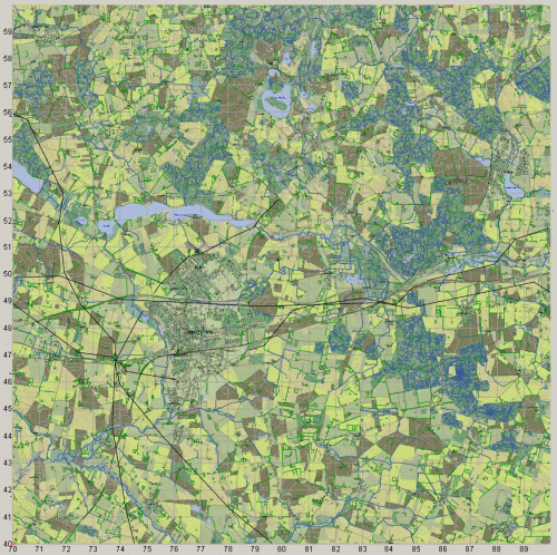
Hannover-Weserbergland-2022-Revision
By Striker
Use this UUID to download this map from the package manager: 9f89ce20-c2a9-4162-a2f4-becb327a9fe1
I'm finally submitting my reworked version of the Hannover-Weserbergland map. This map contains a huge number of visual and operational fixes for a long running map, so it's somewhat hard to put everything into this one post. I will be updating the information occasionally so please check back from time to time. I've spent close to 8 months and about 1200 hours working on it. I've really reached a limit of the amount of time I can spend on it up to this point so I'm submitting it in a fairly close to finished state. What I would like is for everyone that uses this map to spend some time using it and then submit any problems that they find. Please read any other posts carefully to make sure that you are not resubmitting a prior persons post. Also, please try to be as descriptive as you possibly can on the problem that you find along with coordinates. I will not submit another revision for awhile as to keep the number of revisions as small as possible. I will be happy to revise it in the future, but I will collect all of the suggestions and notes about problems, put them together into one master list, and then focus on the most important changes. Feel free to post your list, comments or suggestions here.
There are many problems that exist in a lot of the older maps, and this one really isn't any different. Michael did the best he could at the time adding as many features as possible, but it's really a time consuming project when you dive into working on very large maps such as this one. You will absolutely find that there are areas where towns should be, but there are no buildings. There are also roads that were placed from many years ago when the original map was authored, but no buildings. There are also roads that lead to areas where it doesn't seem to make any sense, usually because they are not complete, again, this is because of when and how the original map was produced. There just simply is not enough time to fill in all the detail in such a large map and I tried to focus on the most important areas. I will absolutely consider extending roads and adding new tows or villages per request. But I wanted to get this version out in it's current state so that the community could have time to use, evaluate, and make suggestions.
I've also spent quite a few hours testing the map using different size areas and have found no problems with loading and frame rates. I was able to do a 22 x 22 km area including most of the Hannover city area and drove a M1 tank through it without any issues. I can not attest to how it will run in a multiplayer scenario. You'll will most likely want to do a test of any area you choose first before spending a lot of time placing units and finding out it has lag problems. Based on my testing though, there should not be any major problems. I would however suggest NOT using the entire East Hannover region as you primary mission focus. I would probably be better for performance reasons to use a section of it as a visual reference or starting point rather than as part of your entire battle plan. Extensive testing will help determine if and what is usable. Please keep in mind that the visual part of the work is only a tiny fraction of the actual goal of the work. The primary goal was to make the map have a functional ability that reflects the actual area without compromising performance.
Some of the important changes:
1. Added all of the Eastern Hannover area including the medical and hospital areas in the Southeast, most of the industrial areas and commercial areas. I also added a lot of the residential areas along with the parks and trees. The city is extremely complex and I tried to model the different structures as best as possible within the limitations of the models available. I also tried to use spacing that makes sense for the highly populated area without creating a loading problem. This also includes all of the roads that crisscross the area and bridges for road and rail lines. I made adjustments to as many of the existing roads as possible so that it reflects the actual locations or as close as possible.
2. I also added three new towns to the East, Hildesheim, Lehrte and Sehnde along with their respective main roads and rail lines.
3. Fixed the VW plant to reflect what it's appearance should be as close as possible using the current modeling. I also fixed a lot of the roadways around Garbsen. I also fixed the Flughafen airport along with the roads and rail lines around it.
4. I fixed the shape of the forests and types of trees around East Hannover and the routing of the Lein river so that it enters the canal along the lake properly.
5. Leveled a very small amount of the terrain, mostly around the VW plant in order to make the buildings look more consistent.
6. Went through the entire map, square KM by square KM, and spliced all roads and rail lines together while cleaning up and smoothing them out. Having continuous and smooth roads helps with path finding immensely. Also, keep in mind that rail lines just like any path on the map can be used for AI path finding. There's no reason to restrict your vehicles to roads only so cleaning up a lot of the broken paths helps a lot in mission design. I also fixed all of the locations of the rail lines so that they are as close to realistic as possible and fixed the junctions of the rail lines in the city areas so they are merged together at the proper points or as close to the actual points as possible. Moved all of the building structures, or as may as I could find off of the roads ( you may find one somewhere but I did a lot of careful looking).
7. Made sure that all bridges are consistent with the type of road surface so that they match and are all passable by AI during pathfinding or route snapping. This is another important aspect of mission building because it helps the mission designer create routes quicker and if the bridge is wrong, the path will be rerouted.
8. Completely redid the city of Rinteln so that the buildings were off of the roads. A lot of the buildings were placed in a hurry and never revised over the years, so many of the surplus structures were all over the city area. I also tried to make the roads as close as possible within some limitations. You'll notice that the Southern side of the river is slightly different that the real map.
9. Reworked the airports so that the runways use asphalt polygons to represent them instead of a bunch of roadways layered.
99 downloads
(3 reviews)0 comments
Updated
-

FT BENNING GA 45km 1A_299vu_BEN_SPLINED
By ben
An edited and improved area of the Ft Benning terrain used in the scenario "The Adventures of Task Force Dagger"
Scenarios that use this map should auto prompt end users to download this map if needed.
To download the map manually, enter: 14ffe367-d7ce-439e-bb71-2233ef7fcd04 into Steel Beasts Map Tools.
66 downloads
-

Updated desert Map "Umm Saad" revision 5b
By Grenny
Added
-a mil. Base close to the Airport
-mil facility in nothern desert
-expanded the Oil-installations in the west
73 downloads
(0 reviews)0 comments
Submitted
-

Utah Beach 44
A 4.1+ map package that depicts the area around Utah Beach in 1944.
Original Height Map was made available by Dark Angel
To download the map, enter: 0e176f0d-3be6-40c3-8ee4-93e0819bf419 into Steel Beasts Map Tools. Scenarios that use this map should auto prompt end users to download this map if needed.
153 downloads
(1 review)0 comments
Updated
-

Bergen-Soltau-Munster
By Abraxas
The map covers the southern part of the "Lüneburger Heide" (Lueneburg Heath) with the cities of Soltau, Munster, Fallingbostel and Bergen as well as the Fassberg airbase and the Unterlüß test area; total size: approx. 2.000 sqkm.
Copyright: This file may only be made available in other forums or on CD/DVD with my written consent!
To download this map, please enter this id into the SB Package Transfer Manager: 6e1be198-486a-46ed-91a5-c37e1762c8d8
Note: This file has not changed since its original version, posted on 10/13/2020. It has been uploaded to the map server.
232 downloads
-

Wolfsburg_Dahlum
By Abraxas
The rar file "Wolfsburg_Dahlum" contains a new basic-map.
To download this map, enter 83b496f3-2e61-490c-99c1-9af48903c8e2 as the map package into the steel beasts map tools UI.
If this map is used in a scenario, it will prompt the user to download as long as they have SB Pro Map Tools installed.
The map section is located in the lower right area of the map. It's the area of the scenarios JERXHEIM and Dahlumer Roulett!
303 downloads
-

Droysiger Forst (Forest)
By Wax Savage
Companion map file to "Droysiger Forst" scenario. 12x12 mile² area. Detailed towns, rivers, rail yard, agricultural fields, etc. Excellent for urban warfare/defense.
To download this map, enter 5cdf46a5-47dd-43a9-9b8d-3d0576837416 as the map package into the steel beasts map tools UI.
If this map is used in a scenario, it will prompt the user to download as long as they have SB Pro Map Tools installed.
42 downloads
(0 reviews)0 comments
Updated
-

Gracac Yougoslavia
By Wax Savage
Companion map file from "UN to the Rescue" scenario. 12 x 13 mile² area. Detailed town, roads, waterways, rail line. Nice map for many scenarios you may design.
To download this map, enter bc6068d8-3b78-4cac-aa4f-d864546807fc as the map package into the steel beasts map tools UI.
If this map is used in a scenario, it will prompt the user to download as long as they have SB Pro Map Tools installed.
53 downloads
(0 reviews)0 comments
Updated
-
Germany Munster 2020a
Truppenübungsplatz MUNSTER Nord & Süd in Deutschland.
Military Training Area MUNSTER North & South in germany.
To download this map, please enter this id into the SB Package Transfer Manager UI: ce2ab58b-be1c-4377-b3fe-28ab0bf25883
NOTE: This map has not changed, but was uploaded to the sb.com map server on 2/23/2022.
Original file date is 6/1/2020.
126 downloads
-
Daru-Sierra Leone 80x80 kms
By ashdivay
Daru-Sierra Leone
Based on the real world location inside Sierra Leone. Daru is a name of a city in SW of this map in Sierra Leone. Since that was the part with woods and other forest i decided to name it.
To download this map, please enter f10d6e6d-6ca0-454b-af9b-c9faad01b55e as the ID into the SB Package Transfer Manager UI.
Note: this map has not changed since 3/29/2021. It has been uploaded to the map server for easy sharing.
Other parts of the map has road network and built-up areas but no forest. Shape data (Roads , buildings by @DarkAngel) Height Data (Me)
95 downloads
(0 reviews)0 comments
Updated
-

Bastogne
By Bond_Villian
Map of Bastogne area and surrounds, made for the SEVEN ROADS TO HELL campaign. Includes fairly accurate locations of roads, railways and villages, large wooded areas etc. Liberties taken with terrain details such as narrow rivers and streams. Terrain is hilly and heavily wooded, theme is winter (snow and ice) with moderate to slow cross-country mobility, and broken (rocky and bumpy) terrain in places. Many small villages and crossroads to fight over, with Bastogne town area included.
To download this map, enter this id into the SB Package Transfer Manager: 1c62d8aa-346d-4dd2-a5b4-9542da4b2e90
The map has not changed since 10/23/2020, it was uploaded to the map server.
209 downloads
(2 reviews)0 comments
Updated
-
![More information about "OTW AI [autocreated base]"](https://www.steelbeasts.com/uploads/monthly_2019_10/137992940_OTWBeaudesertver3.thumb.png.01fff50cfbc212da50fcae9a481d1bd9.png)
OTW AI [autocreated base]
This is the Base map required for the scenario 'Heavy CT Delay v Tank Battalion FD'. Assuming a default file structure, it should be installed to /ProgramData/eSim Games/Steel Beasts/maps/packages.
Important: 'Heavy CT Delay v Tank Battalion FD' also requires the separate Delta map ‘OTW Beaudesert ver 3’ (UID d87bfd19-f78d-4153-ab4c-d7c9935c454b) installed in the /deltas folder of the Base map to work correctly.
Map originally supplied by @Gibsonm.
81 downloads