Pre 4.1 Terrain
88 files
-

Hannover_mtfl_032011_HomeEdition
By manteuffel
I´ve updated the area of DETMOLD and LEMGO and along the Road L712 to BLOMBERG Made this with the 2K glass mode and most of the area is a 1:1 copy :) Enjoy this map :)2,098 downloads
(16 reviews)0 comments
Updated
-

Fulda Gap The Southern Corridor V3
By WarUlf
This is V3 of the Fulda Gap The southern corridor map.2,116 downloads
(15 reviews)0 comments
Updated
-
(14 reviews)
0 comments
Submitted
-

Training Area Münsingen
By Nachtfalke
This training area was closed in 2007 ( South Germany near Stuttgart)563 downloads
-
Central Europe Terrain Map
By Scorpius
Detailed map, requires Ardur Valley height map1,117 downloads
(8 reviews)0 comments
Submitted
-

SCANIASE / Skåne
By AlphaSierra
This is the summer update of ScaniaSE.ter Info: Covers south part of Skåne/Scania province in Sweden. From the city of Lund in NW to the city of Ystad in SE Size: 50 x 50 km Heightmap: Sweden1.hgt (original SB map) Latest updated: 2012-05-18 Stay tuned for new updates ;)1,031 downloads
(8 reviews)0 comments
Updated
-

Training Area Münsingen WINTERVERSION
By Nachtfalke
This training area was closed in 2007 ( South Germany near Stuttgart) This map is a winterversion. Snow Situation like at January to March312 downloads
(8 reviews)0 comments
Submitted
-

Paderborn_0113 (2.654)
By manteuffel
Most of all is complete. Only the Part of Hannover-map must be insert. The Areas at the borders also need a bit improvement. Enjoy the map !1,115 downloads
(7 reviews)0 comments
Updated
-
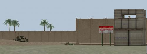
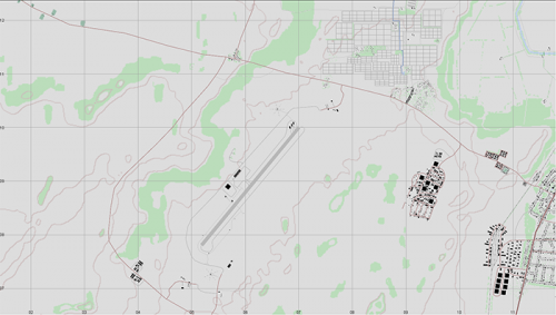
JalibahAirfield terrain map update 2.654
By AlphaSierra
Iraqi/desert map
I have added villages, compounds and updated som of the buildings, not all...
2.640 update contains more villages, roadside marks, bridges and more... enjoy the update!!
I would like to thank the original maker of this map and hope he/she doesn't mind me doing this...812 downloads
(6 reviews)0 comments
Updated
-

Pahkajarvi Training Area, Finland
By Zipuli
This is a map of the Finnish Army training area Pahkajärvi, in south east Finland, near Karelian Brigade. In this area, the Finnish Army conducts live fire exercises and manouvers with infantry, armoured vehicles, anti-tank weapons including ATGMs, mortars, field artillery, multiple launch rocket systems, etc.
- Map size: 20 x 20km, covering the whole training area and its surroundings.
- Height map is DTED3 (10m resolution), 2012 data
- Terrain map by Zipuli and pvt Järvinen, KYMJP
- 5 theme files included for all seasons
See you at Loiri! Bring Your Own Bombs!353 downloads
(5 reviews)0 comments
Updated
-

Schwarmstedt-Bergen-Munster_summer.ter
By Abraxas
From SCHWARMSTEDT in the South-West, crossing River ALLER, NTA BERGEN and MUNSTER-SOUTH towards military airfield FASSBERG and UNTERLÜß in the East. A revised and enlarged map to West-East-grid line 90.5 is available.
Screenshots of the terrain you can see on www.steelbeasts.org/Editorforum/Kartenerstellung/Bergen!
With the version 4.250 this map is no longer required and is automatically replaced by the supplied map "Bergen-Soltau-Munster"!
648 downloads
-
(4 reviews)
0 comments
Submitted
-
(4 reviews)
0 comments
Updated
-

NATO Training Ground BERGEN
By Eisenschwein
Biggest Training Area in GE 18 x 22 Km. Requires the SCHWARMSTEDT - SOLTAU height map.1,740 downloads
(4 reviews)0 comments
Updated
-

Hannover_autumn-mtfl_05_10
By manteuffel
updated the area of Minden and Porta Westfalica. version 2.5xx !!812 downloads
(3 reviews)0 comments
Updated
-

Munster Germany terrain Demonstrator
By DarkAngel
Here is a map of the Munster area in Germany. This map is a request from someone who is working on the map. Please do not edit this version and upload it. It is uploaded to showcase a new way of populating maps with buildings. Where the data is available maps like this are possible in a reasonably short period of time.371 downloads
(3 reviews)0 comments
Submitted
-
Salisbury Plain
By Stuart666
A terrain map of the Salisbury Plain training area in Southern England.574 downloads
(2 reviews)0 comments
Updated
-
(2 reviews)
0 comments
Submitted
-
 (2 reviews)
0 comments
Submitted
-

US Brandenburg Irvington 40x40 km 1.1
By MatsW
Terrain file (version 1.1) for US_Brandenburg_374549N_862821V_40x40.<br /> It's Brandenburg and Irvington area in US, Kentucky. Not Brandenburg in Germany. Height file for the terrain maps is located in the height section. The terrain file is an updated version with more buildings in Irvington area. There will be a 1.2 version with more updates.811 downloads
(2 reviews)0 comments
Updated
-

IRAQ TOWN
By 29 stumps
MY FIRST MAP ATTEMPT, ALSO THANKS TO DASKAL FOR HIS THUNDER ROAD MAP TEMPLAT . ITS JUST A SMALL IRAQ TOWN WITH A LOT OF BUILDINGS AND HWY SYSTEM413 downloads
(2 reviews)0 comments
Updated
-

Newcastle
By companyteam
Approx 20km x 20km. Based on Newcastle (Australia) CBD, although the surrounds are fictitious. Includes port and airport to north, and surrounding farmland and villages. Mix of eastern and western urban areas. Height file updated (thanks to Dark Angel). Minor tweaks in this version of the .ter (bridges and little else). I'll include Dark's Newcastle height file, a file called "trial.hgt" which is the height file I used for the Newcastle .ter (unimaginative, but it was my first go!), and the .ter file itself (v1-1).549 downloads
(2 reviews)0 comments
Updated
-

Salisbury Plain Training AreaV2
By Stuart666
A representation of the Salisbury Plain training area in Southern England. Please delete all pervious versions. The recently released version had a fault that will stop it working correctly. Please update it to this latest version. This includes the new height map Salisbury Plain-0.hgt, which has been causing problems.657 downloads
(2 reviews)0 comments
Updated
-

Um Saad Revisit
By DarkAngel
Here is another map to demonstrate new techniques. This is the Northern border region between Egypt and Libya and was the scene of major fighting in 1977 when these countries had a border war. This map is suitable for someone who wants a small mapping project.371 downloads
(2 reviews)0 comments
Submitted
-
AS Desert (3.002)
By AlphaSierra
Fictional Desert/ME terrain map using the (hgt)kookvalley2048[valley].hgt map. The hgt map contains both rolling hills and extremly flat areas so it's quite suitable for armored warfare! :)
On the terrain map you'll find;
- Major and minor roads and railroads
- Villages
- Cities
- Industrial areas
- Airfield
- Military compounds
- and more... Updated to ver 3.XXX638 downloads